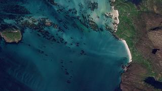
Airbus operates the most comprehensive constellation of optical and radar commercial Earth observation satellites available on the market today. The EODH provides global access to archive data of Airbus optical imagery with 30cm to 1.5m spatial resolution, and radar imagery from 25cm to 40m.
Pléiades Neo. Airbus' most advanced optical satellites with the highest spatial resolution and capacity. Two identical satellites launched in 2021 with seven spectral bands, 30cm native resolution and daily revisit.
Pléiades. Very high-resolution optical satellites with a global archive back to 2012. Two identical satellites with five spectral bands, daily revisit delivering 50cm image products.
SPOT. Efficiently image large areas at 1.5m resolution. Revisit every other day and a global archive back to 2012.
Radar Constellation. Reliably acquires the widest range of radar satellite images, from the highest resolution to wide area coverage - regardless of weather and daylight conditions. Imagery in 6 different imaging modes with a flexible spatial resolution (from 25cm to 40m) and area coverage (footprint). Global mean revisit time < 24 hours, and an archive back to 2007.
Experience the forefront of Earth observation innovation with Pléiades Neo Airbus's leading optical constellation featuring two identical 30cm resolution satellites renowned for their ultimate reactivity. Since its launch in 2021, this innovative constellation has revolutionised the landscape of Earth observation-based services, setting new standards of precision and reliability.
Pléiades Neo can support many application areas including:
Mapping very dense urban areas in Mayotte with Pléiades Neo HD15 imagery
As a result of incorporating recent HD15 imagery into their mapping updates, the local authority has been able to rehabilitate substandard housing and relocate households from high-risk areas.
Detection of Vine Rows using Pléiades Neo Imagery
Understanding the inter and intra-plot heterogeneity of vineyards is a crucial issue in ensuring the stability of wine production and income.
Precision Mapping of Urban Vegetation using Pléiades Neo Imagery
In 2022, Airbus launched the Pléiades Neo Challenge, a call for projects offering free access to Pléiades Neo imagery.
The identical Pléiades 1A and Pléiades 1B satellites deliver 50cm imagery products with a 20km swath. Their location accuracy and image quality are excellent, making them an ideal source of data for both civil or military projects. The space and ground segment have been designed to provide data in record time, ensuring daily revisit capacity anywhere on the globe and unrivalled reliability when it comes to collecting new images.
Pléiades can support many application areas including:
Hijacked Tanker Aris 13 Located with the Help of Pléiades
By combining the Automatic Identification System (AIS) and the Pléiades satellites, Airbus helped locating the ARIS 13 oil tanker attacked by Somali pirates in only 2 days.
Supporting Polio Eradication with help of Airbus Pléiades satellite data
Within the record timeframe of 30 days, an immense area of 50,000km² was acquired with Pléiades in Nigeria.
Simplot develops a scalable system for valuable agronomy
Simplot and Airbus jointly developed a scalable, automated system to collect, process, analyse and digitally display satellite imagery from Pléiades and SPOT 6/7.
The ideal solution for country-wide, demanding applications. Designed to efficiently cover huge areas in record time, making it a perfect choice for cartography and monitoring applications.
SPOT can support many application areas including:
Simplot develops a scalable system for valuable agronomy
Simplot and Airbus jointly developed a scalable, automated system to collect, process, analyse and digitally display satellite imagery from Pléiades and SPOT 6/7.
2018 Hokkaido Earthquake and Post-disaster Monitoring
Japan is constantly under threats from natural disasters. To protect people’s lives and minimise economic losses, the authorities need immediate information from the affected areas.
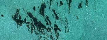
SPOT enables the detection and monitoring of toxic Gulfweed
The gorgeous island of Martinique in the Eastern Caribbean Sea has been hit by a plague, called sargasse.
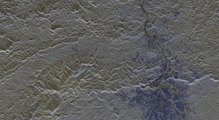
Radar image acquisition in a unique constellation. The German TerraSAR-X / TanDEM-X satellites are being operated in the same orbit tube and feature identical ground swaths and imaging modes. The satellites carry a high frequency X-band Synthetic Aperture Radar (SAR) sensor to acquire datasets ranging from very high-resolution imagery to wide area coverage.
Radar Constellation can support many application areas including: