Keywords: Land and Property, Planning, Urban development, FME, NDVI
“The currency of EO data in identifying newly derelict land gives us an edge as a lot of existing GIS datasets have a lag time and can become out of data quickly due to data collection cycles. There are also minimal existing comprehensive datasets that map existing or potential IOS land. The EO Data Hub connectors enable us to streamline existing manual workflows and give a more targeted approach. We can identify opportunities as soon as they become viable.”
Major urban fringes are the locations of choice for siting fleet storage, EV charging and opportunities for last-mile logistics, with short travel times into dense urban markets. But severe land scarcity and high warehouse rents push demand to outdoor space.
Carter Jonas is a land and property consultancy, providing a range of data insights services to their commercial customers, including both urban and rural landowners who have an interest in maximising usage of their land assets, commercial property investors and infrastructure asset managers.

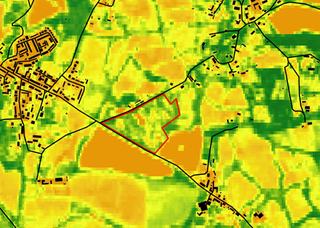
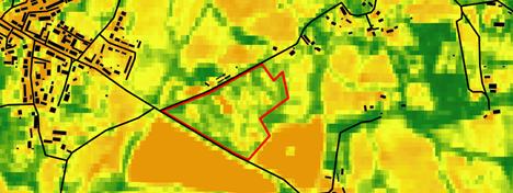
Figure 1: A snapshot NDVI created using 2025 Sentinel shows greater variation in NDVI value on derelict land which creates a speckled effect compared to neighbouring fields.
OS Zoomstack - Contains OS data © Crown copyright and database right 2026.
Contains modified Copernicus Sentinel 2 data 2026.

Figure 2: Polygon delineation of Site A
Industrial Outdoor Storage (IOS) land is increasingly in demand, yet there is limited national‑scale data that tracks existing sites or highlights locations with potential for future development. This creates a need for rapid, evidence‑based methods to identify new IOS opportunities, particularly within urban‑fringe areas.
Vegetation growth can serve as a reliable indicator of dereliction or under‑utilisation in industrial contexts. Monitoring changes in vegetation, such as through NDVI‑based change detection, may therefore help identify land parcels with potential for redevelopment/conversion to IOS use.
Valuation Office Agency (VOA) classifications provide an effective starting point by identifying land already associated with industrial or storage functions, although IOS is not specifically identified and Local Authorities generally have no register of outdoor storage sites. But, when combined with vegetation‑change analysis, these datasets enable Carter Jonas to proactively support investors and occupiers through defensible, data‑driven site identification and selection.
Helen Griffiths, GIS Manager, appreciates the potential of Earth Observation data for identifying phenomena on the ground, both feature identification and land use change.
“The most obvious opportunity from using EO data is the frequency and currency of imagery, but the extra imagery bands from satellites like Sentinel-2 allow you to explore more. You have the opportunity to create your own data points that don’t appear in existing market data products”.
Annie Isaacs, GIS Analyst, used FME Flow together with the NDVI Change Detection workflow provided by Avineon Tensing for creating the vegetation growth (NDVI change) raster.
Relevant storage and industrial VOA categories were selected to give an indication of land used for storage. This point location data was then joined to the HM Land Registry title polygons to provide the parcels of land linked to the land use category. The data was enriched and filtered based on vegetation growth as an indicator of current use and maintenance. As vegetation growth is not solely linked to a piece of land becoming derelict, further analysis needs to be undertaken to rule out parcels of land that have experienced vegetation growth for other reasons.
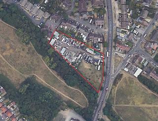
Figure 3: Site A – Intersecting VOA data and vegetation change data created using the Avineon Tensing FME Flow was used to detect land for further assessment.
Source: Esri, Maxar, Earthstar Geographics, CNES/Airbus DS, USDA, USGS,
AeroGRID, IGN, and the GIS User Community
© Google, Airbus
Follow‑up work for Carter Jonas’s Geospatial team will focus on automating this approach through an FME‑based workflow that operationalises vegetation‑change detection and enables subject‑matter experts to define and adjust search criteria, creating a scalable, repeatable site‑identification process.
There is also scope for further optimising the model by including further indicative datasets such as local planning, motorway accessibility, and OS land classifications to give stronger results.
Use of higher resolution commercial imagery or comparison across different time frames/seasons could also be beneficial to optimise the process.
Detecting change which indicates land was previously built on and has dispersed vegetation change has been made possible for Carter Jonas using EO Data Hub.
The value of this approach lies less in time savings and more in its role within a digital twin‑enabled decision framework, where higher‑quality evidence leads to stronger advice, reduced uncertainty, and better commercial outcomes for clients.