Keywords: Foundational Models, Earth Observation, Railway, Transport, Vulnerability
Railway infrastructure faces ongoing risks from land and environmental changes occurring along track corridors. Vegetation encroachment, soil erosion, nearby construction activity, and ground subsidence, can all compromise the safety and performance of rail assets. Traditional inspection methods are labour-intensive, infrequent, and often reactive rather than preventative.
This project set out to develop an operational, satellite-based workflow producing frequently updated ground motion vulnerability maps for railway corridors. The work builds directly on feedback from railway stakeholders gathered during the European Space Agency-funded Earth Observation Best Practices: Road and Rail (EOBP) project, where users highlighted the need for routine, scalable, satellite-based monitoring of land changes and vulnerability analysis around rail assets.
The study was centred on Winchester, Hampshire, covering approximately 10 kilometres of urban and peri-urban railway line with a 500 metre buffer on either side (Figure 1). Its mix of urban development, agricultural land, and river corridors made it an ideal testbed, with the availability of very high-resolution imagery through the EODH hub enabling the surface detail required to detect fine-scale land cover changes across the corridor.
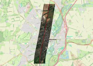
Figure 2: Study area map showing location of Winchester, Hampshire, UK. Red line shows the railway line passing through Winchester. Produced in QGIS
Two acquisitions of Airbus Pleiades Neo commercial imagery at 0.3 m spatial resolution (captured on 21 June 2022 and 18 March 2025) formed the optical backbone of the analysis, with contrasting seasonal conditions helping to distinguish genuine land use transitions from cyclical vegetation patterns. These were paired with openly available ground deformation data from the European Ground Motion Service (EGMS), part of the Copernicus Land Monitoring Service, which provides continent-wide, millimetre-accuracy subsidence measurements derived from European Space Agency’s Sentinel-1 radar satellite. Fusing commercial optical detail with open deformation intelligence gave the project something neither dataset could offer alone: a picture of both what was changing at the surface and what was moving beneath it.
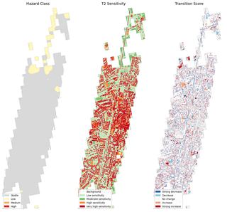
Figure 3: The ground movement hazard (H) (left), the current land cover sensitivity (S) (middle), and the transition score reflecting recent land cover change (T) (right).
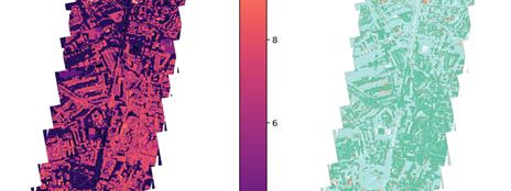
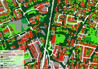
All processing ran within the EODH JupyterHub cloud environment, with DASK distributed computing enabling the workflow to scale across the high-resolution imagery. A staged Python pipeline applied Scikit-learn unsupervised classification to establish baseline land cover. Changen2 was then used to both segment the before and after images into Level 1 land cover classes, and identify transitions between the two time periods. In areas where change was observed, SamGeo was applied to drill deeper, segmenting fine-scale objects including individual buildings and blocks to better characterise the nature and extent of the hotspot. EGMS ground motion data was then integrated to produce a composite vulnerability score calculated as V = 3H + 2S + T, where H is the ground movement hazard, S is the current land cover sensitivity, and T is the transition score reflecting recent land cover change, grouped into five qualitative classes from Very Low to Very High. The weighting gives greatest importance to geotechnical hazard, while still allowing surface conditions and recent change to shape the final result.
All-in-one platform for both data access and analysis
Easy workflow for procurement of commercial data
Potential to work with own datasets in the platform
Integration to QGIS for data exploration is an advantage
Dask offers flexibility and isolated processing environments
Ability to run complex workflows and heavy models, including state-of-the-art foundational models
The results revealed that the Winchester corridor does not behave as a single uniform zone. The central section, dominated by dense urban land cover including buildings, roads, and developed space, sits on largely stable to low-risk ground. Here, vulnerability is driven primarily by the sensitivity of the surrounding land use rather than strong deformation, producing a pattern of generally low to moderate risk with localised pockets where sensitive urban classes and recent changes coincide. The more significant finding emerged in the northern part of the corridor. Before-and-after land cover maps show clear development expansion between 2022 and 2025 in an area that also coincides with relatively higher ground movement risk. New construction advancing towards a railway line on geotechnically uncertain ground is precisely the kind of emerging threat that reactive inspection programmes are poorly placed to catch and exactly what this workflow was designed to surface.
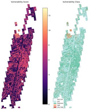
Figure 4: Vulnerability score (V = 3H + 2S + T) (left) and Vulnerability class (right)
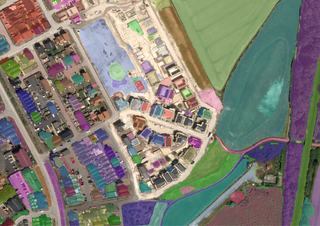
Figure 5: Samgeo - segment everything model output for a hotspot where new development is detected
This project demonstrated the feasibility of a satellite-based railway monitoring workflow, and several directions for future development have been identified. The most immediate priority is to encourage the uptake of high-resolution satellite imagery on a more frequent, operational basis and to apply geospatial foundation models to swiftly detect changes around railway lines at scale. Closer collaboration with infrastructure managers is needed to distinguish operationally critical changes from benign seasonal variation, and to ensure vulnerability outputs translate directly into inspection planning and maintenance decisions. The long-term ambition is a fully automated, quarterly monitoring service delivering timely, evidence-based risk intelligence to railway operators from space.
The EODH platform delivered clear added value throughout this case study. Technical support was responsive and effective, enabling the team to resolve issues quickly and maintain momentum. The procurement of commercial satellite data was straightforward, with a streamlined workflow that removed typical barriers to data access.
As an all-in-one environment for both data access and analysis, EODH significantly reduced the overhead of managing disparate tools and services. The ability to bring in and process user-owned datasets further extends its utility beyond standard EO data offerings.
DASK provided the scalability needed to run computationally demanding workflows within isolated, reproducible processing environments. This flexibility was essential for executing complex pipelines and heavy models, including state-of-the-art foundational models, at the scale required by the case study. Overall, EODH demonstrated strong potential as a platform of choice for operationally demanding EO applications.