Keywords: Local Authority, Heat, Green Infrastructure, Environment
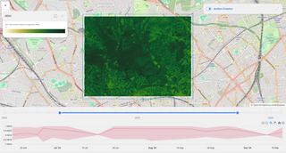
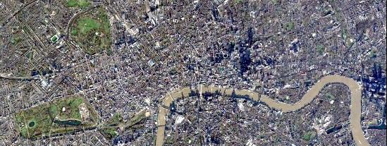
Figure 1: Time series analysis of changes in vegetation, through NDVI measurement, on EODH's EOPro application.
Figure 2: Cloud-free acquisition over London © Airbus DS 2024
The Earth Observation Data Hub (EODH) team have been engaging with multiple London Boroughs, who were looking to understand whether satellite imagery could complement the use of other geospatial data in their current processes. Through the Aerial Photography for Great Britain agreement, Local Authorities have access to high spatial resolution aerial photography. There are challenges with the frequency of this imagery, which is where satellite imagery can be a complementary dataset. The London Boroughs raised challenges with knowing what satellite imagery is available, identifying suitable applications for satellite imagery, and how to access it. The EODH is a one-stop shop for Earth Observation (EO) resources. Bringing together access to different datasets with visualisation and time-series analysis enabled the London Boroughs to gain exposure to various aspects of satellite imagery. This enabled them to build on their existing knowledge.
Due to the numerous access routes within EODH, the London Boroughs were able to choose based on their skillset and operational requirements. The Resource Catalogue enabled an analysis of the datasets available. For example, multiple boroughs were interested in resilience to extreme heat events, so having access to Centre for Environmental Data Analysis’s temperature datasets enabled an investigation into this. In addition, the Climate Asset Risk Analysis Tool (CLARAT) derives hazard indicator datasets from climate projections stored on EODH. CLARAT helps users assess the future exposure and vulnerability of physical assets to climate hazards, such as chronic heat, based on climate projections for various scenarios. As EODH provides cloud computing infrastructure to run workflows, the London Boroughs could reduce hardware strain through processing being shifted onto the Hub.

Figure 3: Output of the Action Creator workflow within EOPro, an application on EODH. Changes in NDVI are shown via a comparison between two points in time.
Another application on EODH is EOPro. The core feature of EOPro is the Action Creator, where users can create customised workflows for processing EO data. It outputs clear visuals and graphical results. London Boroughs highlighted how this type of application is useful for engaging with stakeholders. Accessibility of outputs is important for Local Authorities, as their stakeholders can be wide ranging. The visual nature of satellite imagery, and the hands-on nature of EODH’s applications, increases the accessibility of often complex technical challenges. The London Boroughs explored vegetation health, using Normalised Difference Vegetation Index (NDVI), for green infrastructure planning. There is potential to build on this analysis to inform urban greening projects.
“Workflow builder is intuitive and fast”
“Using open data can enable community and stakeholders to come up with ideas, and have more cases for if they want to purchase imagery for use.”
London Boroughs tend to use open-source software. EODH’s QGIS plugin, for the commonly used open-source geospatial software, proved beneficial for streaming satellite imagery and enabling integration with in-house vector datasets. Local Authorities undertake tasks with wide ranging reporting periods. This includes anything from monitoring planning permission sites, which can involve analysing change over time and monitoring going forward, to identifying areas at risk of flooding, which involves predictive datasets. EODH’s Resource Catalogue provides a single point of access for these datasets.

The London Boroughs highlighted the benefit of producing case studies in a local government setting. As EODH enables quick prototyping and internal advocacy for EO adoption, an increase in use of EODH going forward aims to enable more local authorities to utilise satellite imagery.