Keywords: Environment, Methane Gas Monitoring, Soil Indices, NDVI, NDWI, EO Pro, Drone Survey
Landfill sites are among the largest anthropogenic sources of methane, a greenhouse gas more than 80 times more potent than CO₂ over a 20-year period and responsible for approximately 11% of global greenhouse gas emissions. Despite the scale of the problem, monitoring remains largely manual, relying on infrequent walkovers with handheld devices that leave significant temporal and spatial gaps in coverage.
Drone surveys provide a solution to gapfilling methane data coverage, where commercial tasking of methane Earth Observation missions is inaccessible due to cost barriers for SMEs. Proxies such as soil indices, waste water, and the presence of lichens can be used by correlation to detect the presence of methane gas emissions. As such, investigating the integration of drone survey methane datasets with EO-derived soil indices presented an opportunity to provide a scalable solution to methane gas monitoring at landfill sites.
This project set out to answer a practical question: can open-source satellite data from the Earth Observation DataHub (EODH), combined with machine learning-based anomaly detection, complement the results of a targeted drone methane survey at a regulated UK landfill site?
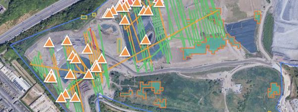
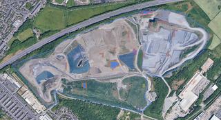
Figure 1: Spatial overlay of UAV-detected methane emission points (orange triangles) and EO-derived DBSCAN-validated anomaly clusters (polygons) at a Landfill Site in North England. Sentinel-2 NDVI/NDWI data processed via EOPro on the EODH platform
🌱 Process and analyse Sentinel-2 multispectral data using NDVI and NDWI indices as indirect proxies for surface methane stress
🚛 Apply Isolation Forest anomaly detection and DBSCAN spatial clustering to produce a machine learning-derived map of potential methane migration zones
🛰️ Compare EO-derived anomaly clusters against ground-truth data from a UAV-based drone survey
🌐 Assess the operational potential of EODH-hosted EO data as a scalable, continuous monitoring layer
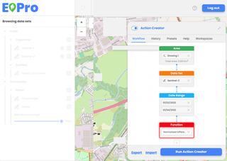
Figure 2: EOPro workflow history
The study was conducted at a large, active regulated landfill in North England, operating a landfill gas extraction and energy recovery system. The drone survey was conducted on 1 March 2022, with Sentinel-2 imagery selected from the same period to ensure temporal alignment.
Sentinel-2 data was accessed and processed via the EOPro application on the EODH platform. NDVI and NDWI index datasets were computed within EOPro by selecting the site area, input dataset and index calculation workflows. Outputs were downloaded as GeoJSON metadata files, providing analysis-ready data for offline analysis using an externally run model. To maximise spatial granularity, the site was divided into multiple sub-area workflows processed independently. Isolation Forest was then applied to assign anomaly scores across the site, with DBSCAN clustering used to validate and group coherent emission anomaly zones for comparison against the drone ground truth.
☑️ Direct access to Copernicus Sentinel-2 open data
☑️ Analysis-ready data outputs from EOPro – no complex preprocessing
☑️ User friendly interface for non-remote sensing experts
☑️ Exportable GeoJSON data for offline ML analysis
☑️ Significantly lowered technical barrier for SMEs
☑️ Simplified workflows reduce the risk of integrating remote sensing into operations
Figure 1 shows a clear visual correspondence in the north-western active tipping zone, where the highest concentration of drone emission points aligns with several EO-derived anomaly clusters, confirming that satellite-detected surface stress signals are present in the same areas where the drone recorded active methane emissions. At full site scale, the EO-derived clusters extend well beyond the drone survey coverage, appearing across the central operational zone, mid-site transitional area, and southern vegetated buffer zones not covered by the UAV flight path.
Viewed independently, the satellite analysis reveals anomalies distributed across multiple zones with no corresponding drone detections. This is a key finding: rather than detecting surface point emissions, satellite indices detect the downstream surface expression of subsurface gas migration, manifesting as vegetation stress (reduced NDVI) and moisture anomalies (elevated NDWI) at locations distant from primary emission sources.
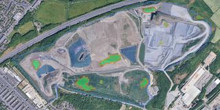
Figure 3: Sentinel-2 NDVI-derived anomaly clusters (green fill, orange outline) across the landfill site, processed via EOPro on the EODH platform. Green polygons highlight zones of statistically significant vegetation stress; red-outlined clusters indicate the highest-confidence anomalies.
The two methods detect different but complementary phenomena:
● Drone survey → active surface emission points in real time
● EO clusters → broader subsurface gas migration zones and diffuse emission risks
Gas migration may be creating surface anomalies across a much wider area than conventional surveys detect, including capped and vegetated zones, making these EO-flagged areas priority targets for follow-up ground investigation. Recycle2Trade work closely with landfill site operators, and the results can go on to inform waste gas-to-energy collection schemes.
Figure 4: Sentinel-2 NDWI-derived anomaly clusters (blue fill, orange outline) across the landfill site, processed via EOPro on the EODH platform. Blue polygons highlight zones of anomalous surface moisture content; red-outlined clusters indicate highest-confidence detections.
“If an SME wanted to integrate remote sensing into operations tomorrow, they must first employ a data scientist with a lot of expertise. After a short tutorial on EOPro, anyone can now do this kind of analysis. Now, many SMEs like us are using remote sensing almost on a day-to-day basis because the availability of different platforms, including the EODH, has decreased the risk of adoption.”
EODH was a critical enabler for Recycle2Trade as an SME. It provided direct access to Copernicus Sentinel-2 data without complex portals, and the EOPro application computed NDVI and NDWI indices in-platform, exportable as GeoJSON files which were analysis-ready for a machine learning pipeline. As landfill and methane domain experts - not satellite specialists - this dramatically lowered the technical barrier to entry. EODH made Earth Observation operationally feasible for them.