Keywords: Tree canopy mapping, Decision making, Real-time insights, Emergency planning, Climate adaption, Sustainability
For many public sector teams, the challenge isn’t whether useful data exists, it’s how quickly they can turn that data into something they can act on. Traditionally, gathering insights about things like tree cover, flood risk, or land use has been slow, manual, and resource intensive. By the time the data is collected, processed, and analysed, the opportunity to act can already be slipping away.
This is where the Earth Observation Data Hub (EODH) is proving transformative.
In a recent project mapping urban tree canopy in Lambeth, what would previously have required extensive cost and effort was completed in a fraction of the time. By combining high-resolution satellite imagery from Planet Labs with cloud-based processing and machine learning, the team at space data company 4EI was able to generate a highly accurate map of tree coverage across the entire borough rapidly and at scale.
The key shift wasn’t just better data; it was speed and accessibility. The EODH removed the need for local infrastructure, enabled direct access to large datasets, and used scalable computing power to process complex information quickly. Tasks that would normally overwhelm standard systems were handled seamlessly in the cloud, compressing timelines from days or weeks into hours.
The real value of this approach is that decisions that were once delayed by data bottlenecks can now be made while they still matter.
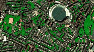
Figure 1: Detection of tree canopy extent around Kennington Oval
Faster access to insights isn’t just a technical improvement, it fundamentally changes how organisations operate. We have many more examples on our website, they cover many other use cases, and they clearly demonstrate the real value of the EODH:
Planning becomes proactive, not reactive
Instead of relying on outdated surveys, planners can work with near real-time evidence of how environments are changing.
Resources can be targeted more effectively
Whether it’s planting trees, managing heat risk, or prioritising flood defences, decisions can be based on more current, relevant information, and not backward-looking models that no longer represent our current reality.
Teams don’t need to be technical experts
By simplifying access to complex datasets, the EODH helps translate specialist data and models into something usable for everyday decision-making.
Innovation can be deployed rapidly for impact
By reducing technical costs and complexity EODH helps provide the environment for rapid deployment and testing of novel models for impact and value creation.
The benefit is not the platform itself it is the time saved, risks reduced, and better outcomes delivered. The story is not about GPUs or data pipelines; it’s about enabling faster, more confident decisions, and providing easier access to data through the UK’s world leading space-based data expertise.
Jonathan Hendry, CTO clearly articulates the value and impact
"By leveraging the EODH capability during our urban tree canopy mapping project in Lambeth, we saw firsthand how cloud-based processing eliminates traditional data bottlenecks. What used to require thousands of pounds, a lot of effort, and 3-4 days or weeks of manual work was compressed into just hours of high-value insight."
While the Lambeth example focuses on tree canopy, the same approach applies far more broadly. The EODH has the potential to support:
Emergency planning – enabling earlier identification of flood risks and faster coordinated responses
Climate adaptation – helping authorities anticipate and respond to extreme heat and environmental stress
Urban growth and regeneration – identifying where investment will have the greatest long-term impact
Sustainability goals – tracking emissions drivers and environmental change across estates and regions
In each case, the transformation is the same: moving from slow, fragmented, and reactive processes to fast, integrated, and insight-driven decision-making.
The Earth Observation Data Hub demonstrates what is possible when data, infrastructure, and usability are brought together. It shows that complex environmental insights can be delivered quickly, at scale, and in a way that supports real-world decisions.
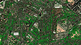
Figure 2: Overview of the tree canopy extent detection over Stockwell, Lambeth
But to fully unlock its potential, the focus must remain on outcomes, not just capability. The real value lies in:
Ultimately, the transformation is simple but powerful, from data that is complex to access and use, to insights that drive action, at the speed that modern challenges demand. We encourage any end user or analytics company to test the infrastructure to see how it can truly support our decision making across the UK for societal and economic benefit.
To engage with the team at EODH, please contact enquiries@eodatahub.org.uk to get started.
We are an EO data catalogue and processing platform supporting all users across the boundaries of industry, public sector, and research. We provide a single-point of access to quality-assured commercial and open EO datasets, as well as interfaces and integrations suitable for GIS Analysts, Data Scientists and EO Developers.