Keywords: Historic Environment, Conservation, Government, GIS, ArcGIS Pro, Cloud-Optimised GeoTIFF (COG), Very-High Resolution (VHR)
Historic England is a public organisation that protects and brings new life to the heritage that matters to us all, so it lives on and is loved for longer. As the Government’s statutory advisor on the historic environment in England, its role includes championing, understanding, identifying and protecting our heritage. This includes managing the National Heritage List for England which includes 400,000 items ranging from prehistoric monuments to office blocks, battlefields and parks.
The Yorkshire Wolds Archaeological Landscape Project is a part of Historic England’s ongoing programme of large-area aerial mapping projects which map and record sites and landscapes of historical and archaeological interest across the country. In combination with using standard sources of traditional aerial photographs, both vertical and oblique, and lidar data, Historic England is also examining some of the Copernicus Contributing Mission imagery, freely available to them as a government agency.
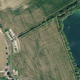
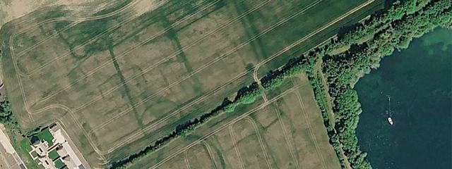
Figure 1: An Airbus image showing what archaeological features can be seen under optimal conditions. A probable prehistoric enclosure showing as differential growth in a crop located near Ashton Keynes, Wiltshire © Airbus DS 2025
Look for cropmarks with differential colouring to delineate lines indicating past presence of a historic structural feature
Conditions such as season, soil moisture, weather, and harvest affect visibility of cropmarks. Summer (May-August) is the ideal season for observation
Integrate Earth Observation data with other data sources such as aerial photography
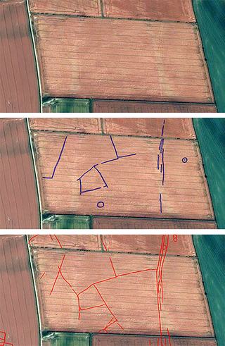
Figure 2: A series of images showing the original satellite image (top), the archaeology mapped from the image (centre) and the total of previously recorded archaeology using earlier aerial sources (bottom). Apart from the probable prehistoric enclosure (centre) there are traces of other related field boundaries and a possible trackway (right) © CNES (2024), Distribution Airbus DS
The Earth Observation DataHub (EODH) presented an opportunity to integrate Very High Resolution (VHR) imagery to see how it compared as a resource. This helped the organisation to assess the potential value of using commercial satellite data in combination with conventional aerial imagery, including facilitating a cost-benefit analysis. Similarly, the Resource Catalogue was able to expose additional Earth Observation (EO) datasets which were novel to the organisation and could be explored for their usefulness in future projects and use cases.
Historic England are existing users of modern and historical remote sensing data to create maps of multi-period archaeological landscapes, and all of their analysis is done in ArcGIS Pro. However, their use of satellite-based EO data is currently limited and relates almost exclusively to the visual examination of imagery for the discovery and monitoring of features or landscapes.
In the past, they have experienced challenges integrating EO datasets due to varying spatial projections and excessive download capacity of large image files. Co-registration of image layers with different reference systems on the map proved difficult, leading to challenges producing accurate maps of the data. Accessing the most relevant parts of a given swathe was problematic, since data downloads often deliver full scene footprints, leaving a lot of redundant data outside their Area Of Interest (AOI) that was annoying and wasteful in terms of time and storage. Finally, spatial resolution of the data was critical to its usefulness at Historic England, with low resolution limiting suitability of the data for identifying archaeological features.
Historic England set out to address 3 key goals:
To integrate VHR commercial Airbus Pléiades (50cm) data, acquired through the EODH, in ArcGIS, as well as explore opportunities to integrate additional open-access EO data for land use and climate variables from the Hub. This data would complement other remote sensing datasets being implemented for their work on the Yorkshire Wolds Archaeological Landscape Project.
To address their specific challenges and barriers to using EO data outlined above.
As well as utilising EO data for a specific project, Historic England set out to further improve their long-term usage of EO within the organisation, by using the EODH to help them develop appropriate standards and guidance in using satellite data adopted by the wider sector.
"Just using the data from Copernicus directly through download and unzipping, understanding all the different projections and everything else, we found there were several practical issues: multispectral band orders not matching expectations, causing images to load with incorrect colours; manual symbology fixes were needed; and repeating those fixes across county‑wide workloads became a lot of work just to see what should simply be an image. By contrast, having the data from the EODH that you just unzip, load in, and it’s already in the right place with the right symbology saves a great deal of time. It is definitely one of the beauties of the data that comes in from the EODH: it's just what you need, it's in the right place, and it shows what you want to see."
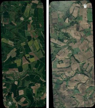
Figure 3: Yorkshire Wolds Archaeological Landscape project site, captured by Pleiades in May 2024 (left) and September 2024 (right). © CNES (2024), Distribution Airbus DS
Catalogue search filtering on temporal metadata to achieve optimal conditions for cropmarks
Provision of commercial image thumbnails to check for visual features in advance of ordering the data
Delivered commercial scenes clipped to a predefined area of interest, avoiding download and storage of redundant data files
Cloud-Optimised GeoTIFFs (COGs) allow seamless visualisation in GIS software, solving the challenge of varying projections and co-registration
Using the Resource Catalogue, 7 cloud-free scenes were found for the months of May through August, for consecutive years, covering a defined boundary for the wider Yorkshire Wolds project area. Commercial scene acquisitions were delivered to their workspace clipped to the AOI boundary they had defined, and in Cloud-Optimised GeoTIFF (COG) format optimised for web mapping.
Figure 4: A heavily processed image, edited to highlight a probable prehistoric enclosure showing as differential growth in a crop located near Duggleby, Yorkshire from Airbus Pléiades imagery purchased from the Earth Observation DataHub © CNES (2024), Distribution Airbus DS
The key finding from the trial was the greatly improved ease of use of the data, which could be quickly added into ArcGIS and did not require additional processing.
The actual imagery used in the test was not particularly successful, with only a few features showing as cropmarks, and these were not particularly well defined. However, this was not due to the nature of the data, but rather to the complexities surrounding the formation of cropmarks. These rely on a series of factors, including, but not limited to, the nature of the underlying geology, the crop being grown and the prevailing weather conditions. Due to the limited number of images available for the trial, it was always uncertain as to whether any would have been captured under optimum conditions. We know from analysis of other Airbus data visible on Google Earth that, given the right conditions, the results can be spectacular.